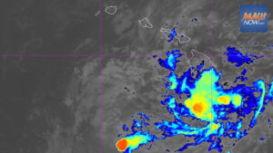

Forecasters are monitoring a low pressure system SE of Hawaii that has rapidly organized today, with a well-defined low-level center now evident on satellite, according to the National Weather Service. Although showers and thunderstorms remain disorganized, the disturbance sits about 1,050 miles east-southeast of the islands and is moving west-northwest near 15 mph.
Environmental conditions are expected to favor additional strengthening, and forecasters say a tropical depression or tropical storm is likely to form on Wednesday. The chance of formation remains high at around 90 percent through 48 hours and over the next seven days. Officials advise residents across the state to closely track updates.
Low pressure system SE of Hawaii could develop quickly
Earlier Tuesday, the National Hurricane Center said it was following a broad area of low pressure about 1,200 miles east-southeast of Hawaiʻi with showers and thunderstorms that were still disorganized but showing signs of reforming. The outlook called for a 70 percent chance of development within 48 hours and a 90 percent chance within a week.
While the eventual track and intensity remain uncertain, the National Weather Service noted that potential impacts could arrive as soon as this weekend. Possible hazards include critical fire weather conditions, strong winds, heavy rain, and large surf.
Emergency officials urged residents to prepare now and stay informed through official forecasts and alerts. Hawaiʻi County Civil Defense said households should plan for possible heavy rain and high winds as early as Friday evening.