

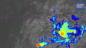
Tropical Storm Lala is poised to strengthen and make landfall on the Big Island as a hurricane on Saturday, a rare event that scientists say reflects both this summer’s powerful El Niño and long-term warming trends affecting Hawaiʻi.
For years, some researchers described Hawaiʻi island as acting like a rock in a stream, forcing steering winds to divert storms. Retired University of Hawaiʻi professor Tom Giambelluca, who oversees the state’s Mesonet System of weather stations, said the island’s towering 13,000-foot peaks do help shield certain areas. Still, the reasons storms have typically weakened or veered away before striking Hawaiʻi are complex.
This season’s unusually strong El Niño is a major driver behind Lala, which is expected to become the first hurricane to make landfall in Hawaiʻi since Iniki in 1992. Scientists caution residents to prepare for more activity in coming years as a warming climate shapes conditions across the islands.
“I often tell students that El Niño is like a practice run for climate change,” said Alison Nugent, an associate professor in UH’s Department of Atmospheric Sciences, noting that higher baseline temperatures are likely to persist beyond the current El Niño cycle.
Sea surface temperatures south of Hawaiʻi island are currently between 80.6 and 82.4 degrees Fahrenheit. (Courtesy: National Weather Service Climate Prediction Center/2026)
What is powering Tropical Storm Lala
Historically, relatively cool waters and disruptive wind shear helped prevent storms from reaching the islands at hurricane strength. A tropical storm becomes a Category 1 hurricane when sustained winds reach 74 to 95 miles per hour.
Forecasters now expect Lala to intensify rather than fizzle, raising questions about climate change’s influence. Warmer ocean waters are a clear factor, Nugent said. Hurricanes draw energy from latent heat released when water vapor condenses. With warmer seas, there is more potential fuel for stronger systems.
Of the five named storms that have made landfall in Hawaiʻi over the past 67 years — Hurricane Dot in 1959, Hurricane Iniki in 1992, Tropical Storm Iselle in 2014, Tropical Storm Darby in 2016 and Tropical Storm Olivia in 2018 — three occurred in the last decade. Climate modeling published in 2016 projected a significant increase in the number of hurricanes near Hawaiʻi in the coming decades.
Kauaʻi’s Coco Palms resort, shown in March, was destroyed by Hurricane Iniki in 1992 and has not been rebuilt. (Craig Fujii/Civil Beat/2026)
Sea surface temperatures are a key threshold. Hurricanes do not typically form when waters are below 79 degrees Fahrenheit. Once they reach around 80 degrees, conditions become favorable. On Thursday, waters south of the islands ranged from 80.6 to 82.4 degrees.
El Niño, climate change and uncertainty
Exactly how much climate change is driving Tropical Storm Lala is not fully resolved. El Niño, a natural warming pattern in the tropical Pacific that cycles every four to seven years, is also elevating temperatures this season. Some researchers argue that long-term warming may be amplifying El Niño, though that remains under debate.
“The relationship between El Niño and climate change is not well-documented or understood,” said Steven Businger, a professor and former chair of UH’s Atmospheric Sciences Department.
Tracks of Dot, Iniki, Iselle, Darby and Olivia, the largest storms to make landfall in Hawaiʻi since 1959.
Businger noted that many sea surface temperature changes are being driven by boundary currents feeding warmth into midlatitudes around 45 degrees north. Hawaiʻi, at roughly 20 degrees north, sits in a region that has seen comparatively little long-term change.
“If you look at sea surface temperature change over the last few decades, Hawaiʻi is in a special pocket of very little change,” he said.
Lessons from Hawaiʻi’s storm history
Businger has traced the islands’ hurricane history back to 1871, turning to Hawaiian-language newspapers that documented a powerful Big Island storm largely overlooked in English-language accounts of that era. A 2018 study by Businger and colleagues detailed damage along the Hāmākua Coast and in Waipiʻo Valley.
“The greatest fury was say from 9 to 9:30 or 9:45, torrents of rain came with it. The district is swept as with the besom of destruction. About 150 houses were blown down,” reported the Aug. 24, 1871, issue of Ke Au Okoa, describing uprooted kukui trees and extensive damage to mills and homes.
The system then impacted Maui, damaging parts of Hāna, Wailuku and Lahaina. In Wailuku, the Aug. 26, 1871, Ka Nupepa Kuokoa likened a collapsed bridge to an overturned ship.
What happens after Tropical Storm Lala
If Lala causes significant impacts, researchers may launch an attribution study to evaluate whether and to what extent human-caused climate change altered the likelihood or severity of the event. Groups such as World Weather Attribution often publish rapid analyses within days.
Whatever the conclusions, Businger said warm sea surface temperatures are expected to persist through winter.
“This is the year for storms,” he said. “Warm water sticks around for a while, so next summer will also have the potential to create problems.”
Earlier this week, forecasters reported that Tropical Storm Lala forming unusually close to Hawaii was already raising concerns about impacts across the islands.











One Response