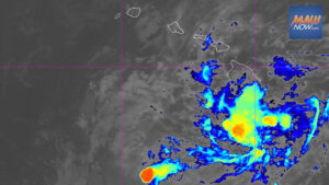

Tropical Depression Two-C is being closely watched by forecasters as Hawaiʻi Island continues to recover from Hurricane Lala. Officials say the system is expected to bring heavy rain to the Big Island starting Saturday night, with impacts spreading west across the state into early next week.
According to the National Hurricane Center, the disturbance in the East Pacific strengthened into Tropical Depression Two-C with sustained winds near 35 mph. As of the late-morning advisory Thursday, it was about 900 miles east-southeast of Hilo and moving west-northwest at 15 mph. On its current track, the center is expected to pass near or south of the Big Island this weekend. While the exact path and intensity remain uncertain, county officials urge residents to prepare for another round of severe weather.
Tropical Depression Two-C rainfall outlook
Heavy rainfall associated with the system could begin late Saturday on the Big Island, then push west to the rest of the islands Sunday into Monday. Forecast totals for Hawaiʻi Island are 5 to 10 inches, with isolated amounts up to 15 inches. The remaining islands could see 1 to 3 inches, with localized totals near 5 inches. Forecasters warn that this rain could cause life-threatening flooding and mudslides, especially in steep areas and places recently impacted by Lala.
Winds and surf
Forecasters say there is a risk of wind and wave impacts statewide regardless of the precise track. Watches could be posted for parts of the islands Thursday night or Friday. The cyclone is expected to traverse a generally favorable environment over the next couple of days, allowing gradual strengthening to a strong tropical storm or possibly a Category 1 hurricane as it approaches the islands. Swells generated by the system are likely to reach portions of Hawaiʻi this weekend, bringing dangerous surf and rip current conditions.
Storm’s name
Tropical Depression Two-C will receive a name if its winds reach at least 39 mph. If it achieves tropical storm strength in the Central Pacific, it will be named Moke, a historical Hawaiian equivalent to Moses. If it is upgraded while still in the East Pacific, it would take the name Iselle, the same name used for the system that struck parts of the Big Island in August 2014.
Other tropical disturbances in the Pacific
Forecasters are also tracking two additional systems farther east. Disturbance 2, a weak area of low pressure several hundred miles south of the southern tip of the Baja California Peninsula, is producing widespread disorganized showers and thunderstorms. Conditions are marginally favorable, and it has a 40 percent chance of developing into a cyclone over the next seven days.
Disturbance 1, a tropical wave a few hundred miles south of southern Mexico, is generating gusty winds and disorganized showers and storms. Environmental conditions appear favorable for gradual development, and a tropical depression is likely to form this weekend or early next week as it moves west-northwest.
Residents across Hawaiʻi are encouraged to monitor updates from the National Weather Service and Hawaiʻi County Civil Defense, secure storm supplies, and prepare for possible flooding, high surf, and rapidly changing conditions this weekend.