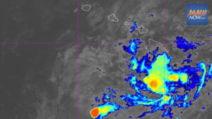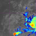

Tropical Storm Moke strengthened slightly overnight and remains on a track that will take it a couple hundred miles south of Hawaii island late tonight, then farther south of the rest of the state Sunday and Monday, according to forecasters.
As of 5 a.m., Tropical Storm Moke had maximum sustained winds of 50 mph and was centered about 470 miles southeast of Hilo, moving west-northwest at 12 mph, the Central Pacific Hurricane Center said. Tropical storm-force winds extended up to 115 miles from the center.
Tropical Storm Moke to bring heavy rain and gusty winds
The system is expected to deliver gusty winds and periods of heavy rain to Hawaii island beginning tonight, with rainfall totals of 5 to 10 inches and localized amounts up to 15 inches possible on windward and southeast slopes, the National Weather Service said. A flood watch is in effect for the Big Island from late tonight through Monday afternoon.
Forecasters noted that saturated ground from recent heavy rain will increase the risk of flash flooding, especially as the island continues recovering from Hurricane Lala’s impacts last weekend.
Eastern Maui could see 1 to 2 inches of rain, with localized totals up to 4 inches, while the rest of the state may pick up 1 to 2 inches.
A wind advisory is posted from noon today through 6 p.m. Sunday for portions of Maui, Molokai, Lanai, Kahoolawe and Hawaii island. East-northeast winds of 25 to 35 mph with gusts up to 55 mph are possible, particularly over ridges, gaps and downslope areas.
Forecasters warned that winds this strong can damage shingles, down tree branches, blow away tents and awnings, and make driving difficult for high-profile vehicles.
Track, intensity and watches
Forecasters said Moke is smaller than Lala and is projected to pass much farther south than last weekend’s cyclone, which lingered near South Point on Aug. 15 as a Category 1 hurricane before skirting just south of the smaller islands through Monday.
Given Moke’s compact size and high confidence in the short-term track, tropical storm watches or warnings are not anticipated for Hawaii. However, gusty winds are still likely in parts of the islands, especially over higher terrain, from late tonight into early next week.
Most of the storm’s moisture is on the north side of the circulation, so areas under that quadrant are expected to see the heaviest rain.
Maximum sustained winds may peak near 60 mph later today, then gradually weaken over the next four days as the storm moves past the islands. The latest five-day forecast cone keeps all islands outside the cone of uncertainty, indicating a direct hit is not expected.
Reconnaissance, surf and broader tropics
NOAA and U.S. Air Force Hurricane Hunters have been flying missions in and around the system to collect data and are slated to investigate again later today, officials said.
High surf is expected to build along east and south shores over the next few days as swells from the storm arrive. These swells may produce life-threatening surf and rip current conditions, according to the hurricane center.
No surf advisories or watches were posted early this morning.
In the East Pacific, the National Hurricane Center in Miami is monitoring three disturbances south of Baja California that could develop into tropical cyclones over the coming week.