
Editor’s note: This story was updated on July 26, 2026, at 4:49 p.m.
Hurricane Fausto is holding steady in the Central Pacific, and Hurricane Fausto was about 740 miles east of Hilo as of the late afternoon advisory, according to forecasters and Hawai‘i County officials.
County civil defense reported Sunday morning that the system is expected to pass north of Hawai‘i Island late Monday or early Tuesday. Residents statewide are urged to secure property for possible strong winds and heavy rain. Forecasters say warning-level surf for north and east shores could begin tonight and persist through Wednesday.
As of the 5 p.m. update from the National Hurricane Center, Fausto was moving west at about 15 mph, a slight increase from earlier in the day. Maximum sustained winds eased to 85 mph from 90 mph.
Current projections call for the cyclone to weaken to a tropical storm as it passes north of the state. The most intense thunderstorms are becoming displaced from the low-level center, with stronger winds mainly on the northern side of the circulation. Given the increasingly sheared structure, the risk of sustained tropical-storm-force winds on land remains low if the track stays north of the islands.
Even so, the National Hurricane Center expects swells from the hurricane to reach the state ahead of the core of the storm. The resulting surf and rip currents will increase and spread westward across the island chain over the next few days. No coastal watches or warnings are in effect, but officials urge the public and stakeholders to follow updates closely.
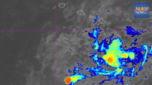
Hurricane-force winds extend outward up to 45 miles from the center. Tropical-storm-force winds reach outward up to 175 miles. Gradual weakening is forecast through the next several days. Satellite imagery Sunday showed the convective pattern deteriorating, with mid-level dry air eroding deep convection over the eastern semicircle and signs of eyewall erosion on microwave scans. Simulated satellite guidance also shows continued weakening late July 26 into early this week.
A strong subtropical ridge continues north of the system, and track guidance remains in good agreement through about three days, with more spread thereafter as the center passes north of the islands. Southwesterly vertical wind shear is expected to increase within the next day, which should contribute to further weakening.
Hurricane Fausto expected to boost surf and rip currents
Young Brothers said Saturday it had not adjusted barge schedules but warned that increased harbor surge from the storm could cause delays or affect safe berthing and cargo operations.
The U.S. Coast Guard has set Port Heavy Weather Condition Whiskey for all commercial ports in Hawai‘i as of 8 p.m. July 24 because of the potential for gale-force winds over the coming days. Ports remain open to commercial traffic and transfer operations, with the following measures in place:
- All pleasure craft should move to sheltered waters.
- Operators of vessels 200 gross tons and greater should plan to depart port. The captain of the port may direct departures to reduce the number of vessels in port.
- Vessels requesting to remain in port must submit a safe mooring plan and receive written approval from the captain of the port and the Hawai‘i Department of Transportation Harbors Division.
- Submit requests immediately. Requests received after Port Condition X-Ray may not be considered. Send to D14-DG-SH-SecHono-MTSRU@uscg.mil and HawaiiDistrict.heavyweather.request@hawaii.gov.
- Vessels transiting near the Hawaiian Islands should seek shelter and anticipate additional restrictions or potential port closures as conditions evolve.
- The captain of the port may restrict or deny entry to vessels carrying oil or certain hazardous materials.
- If Port Condition Yankee is set, meaning sustained tropical-storm-force winds of 39 mph are expected within 24 hours, ports will be closed to incoming traffic without specific approval.
For port status questions, contact the Maritime Transportation System Recovery Unit at D14-DG-SH-SecHono-MTSRU@uscg.mil or U.S. Coast Guard Sector Honolulu Command Center at 1-800-552-6458.
Preparation tips as Hurricane Fausto approaches
National Weather Service forecasters in Honolulu and Hawai‘i County officials are urging preparedness regardless of the storm’s exact track. Recommendations include:
- Check emergency kits and stock at least 14 days of food, water and medications.
- Confirm family communication plans and evacuation options.
- Know your zone by checking if you live in a flood-prone or wind-exposed area.
- Prepare your home by trimming trees, clearing gutters, sealing gaps and securing loose outdoor items. Review insurance coverage.
The county also recommends:
- Make a plan to shelter at home or move to a safe location before conditions deteriorate.
- Trim vegetation that could fall and damage structures.
- Clear debris to keep drainage paths open.
- Ensure food, water and medications are stocked for all household members, including pets.
- Prepare for possible power outages.
Sign up for Hawai‘i County Civil Defense alerts at https://bit.ly/HCCDAlerts.
Other tropical activity and surf advisory
A reconnaissance mission by U.S. Air Force Reserve Hurricane Hunter and NOAA aircraft was scheduled for Sunday to sample Fausto, which will help refine subsequent intensity and track forecasts.
In the East Pacific, Genevieve rapidly intensified into a hurricane Saturday and was located about 500 miles south-southwest of Manzanillo, Mexico, by late evening. Sustained winds were near 90 mph while the storm tracked west-northwest around 17 mph. Gradual weakening is expected to begin after about two days as the cyclone moves over cooler water and into drier, more stable air, though it is forecast to remain a hurricane through the week. Hurricane-force winds extended up to 40 miles from the center, with tropical-storm-force winds out to 195 miles.
Separately, a high surf advisory for south-facing shores statewide, unrelated to Fausto, was extended through 6 a.m. Sunday. Surf of 7 to 10 feet and strong currents will keep ocean conditions hazardous along south exposures.
High surf advisory for south-facing shores statewide coverage includes more details on recent south shore conditions.
The Trade Wind will provide further updates as Fausto continues to move toward the state.