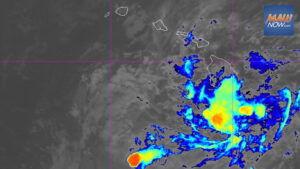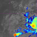

Hurricane Fausto is forecast to pass north of the Hawaiian Islands on Tuesday and Wednesday as a tropical storm, according to the National Weather Service. Forecasters expect a return to a drier, breezy trade wind pattern statewide from Thursday as Hurricane Fausto tracks west and away from the state.
Meteorologists said the atmosphere ahead of the system will become less favorable as it nears the islands, leading to weakening before it reaches the vicinity of Hawaii. They cautioned, however, that even a slight southward shift in the track or slower weakening could change island-by-island impacts. Residents are encouraged to monitor updates closely as conditions will evolve as the system approaches.
Hurricane Fausto forecast and potential impacts
High surf is expected along east-facing shores today through Tuesday, possibly exceeding warning levels. A High Surf Advisory is in effect for east shores through Wednesday and could be upgraded if wave heights increase further.
The National Weather Service said strong winds to around 40 mph may develop near and north of the low center from Tuesday into Wednesday, with the potential for periods of heavy rain during that timeframe.
As of 5 a.m., the Central Pacific Hurricane Center placed the center of Fausto near latitude 20.7 North, longitude 146.2 West. The system was moving west-northwest at about 14 mph, with a general west to west-northwest track expected over the next several days.
Maximum sustained winds were near 80 mph with higher gusts, and gradual weakening is forecast. Hurricane-force winds extended up to 35 miles from the center and tropical-storm-force winds up to 140 miles. Estimated minimum central pressure was 986 mb, or 29.12 inches.
Trade winds, preparedness, and marine conditions
A strong high pressure system well north of the islands will maintain moderate to breezy trade winds today, with typical windward and mauka showers mainly overnight and during the early morning hours.
Emergency managers advise households to maintain at least a 14-day supply of food and water during the current hurricane season, which runs through the end of November.
Mariners and beachgoers should use caution along exposed east-facing shores as Hurricane Fausto continues west across the Central Pacific, with elevated surf and strong currents expected.
For more on the storm’s earlier track, see Hurricane Fausto Friday update: Risk of impacts rising. Additional seasonal guidance is available from the Ready.gov hurricane preparedness page.