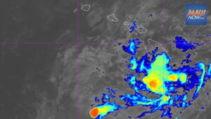

Hurricane Fausto remained a Category 1 system this morning as it moved toward Hawaiian waters, but forecasters expect Hurricane Fausto to weaken today while tracking just north of the state Tuesday and Wednesday.
There are no coastal watches or warnings for land areas. A tropical storm warning is in effect for the waters surrounding the islands, according to forecasters.
A high surf advisory for east shores of all islands runs through 6 p.m. Wednesday, driven by swell from Hurricane Fausto. Surf is forecast to build to 10 to 14 feet, and the advisory could be upgraded to a warning as the swell peaks tonight into Tuesday. Officials cautioned that large surf and strong currents will create dangerous conditions along exposed shores.
As of 5 a.m., Fausto was about 580 miles east of Hilo with maximum sustained winds near 80 mph, moving west-northwest at 14 mph. Hurricane-force winds extended up to 35 miles from the center, and tropical storm-force winds extended outward up to 140 miles.
Forecasters with the Central Pacific Hurricane Center said Fausto will continue west-northwest and is expected to pass north of the islands Tuesday into Wednesday. The environment ahead of the system becomes less favorable near the state, and Fausto is forecast to weaken to a tropical storm before it nears the vicinity of the islands.
The latest five-day forecast map shows only Kauai at the southern edge of the cone of uncertainty, indicating a low chance of a direct impact for the other islands. By Tuesday afternoon, as the system passes north of Maui County and Oahu, maximum sustained winds near the center offshore are expected to be around 45 mph.
Forecasters cautioned that even small southward shifts in the track or slower weakening could change impacts to the islands. They urged the public to closely monitor updates as conditions will evolve as Fausto approaches.
Beyond the high surf, potential impacts with lower confidence include periods of strong winds and heavy rain from Tuesday through Wednesday.
Hurricane Fausto marine and surf outlook
The tropical storm warning for Hawaiian coastal waters calls for northeast winds of 15 to 25 knots and seas of 7 to 10 feet today, building to near 16 feet Tuesday. The warning remains in effect through Thursday, when Fausto is expected to dissipate northwest of Kauai.
After the system moves by and weakens, drier and breezy tradewind weather is expected across the state starting Thursday.
Hurricane Fausto island forecast
Today on Oahu, expect scattered windward and mauka showers, isolated leeward showers, northeast winds 15 to 20 mph, and highs from 85 to 90 degrees.
Tuesday and Wednesday will be similar, with numerous windward and mauka showers during the day. Winds will shift to the north, then east. Leeward areas are also likely to see more daytime showers on Wednesday.
Officials on Oahu have already begun to review storm readiness as Hurricane Fausto approaches the region.