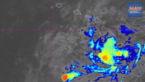

Potential Tropical Cyclone One-C was about 775 miles east-southeast of Hilo and 985 miles east-southeast of Honolulu as of 11 p.m. Aug. 12, moving west at 10 mph with maximum sustained winds near 45 mph. A shift to a west-northwest track is expected today, and officials advise residents statewide to monitor updates and finalize preparedness plans.
Forecasters said it is still too early to pinpoint the exact location and severity of impacts from Potential Tropical Cyclone One-C, but a hurricane or tropical storm watch will likely be issued for part of the state by early today.
Potential Tropical Cyclone One-C rainfall and wind risks
Heavy rain associated with the system is expected to reach the Big Island on Aug. 14, spreading west across the island chain through the weekend. Totals of 5 to 10 inches are forecast across many areas, with localized amounts up to 20 inches possible. Forecasters warn of life-threatening flooding and mudslides, especially in steep terrain.
Regardless of the exact track or intensity, the risk of strong winds and hazardous seas is increasing. Probabilities indicate sustained winds of 50 to 60 mph are possible over large portions of Hawaiʻi Island. Swells generated by the disturbance are expected to reach east-facing shores Friday, then build and spread west through the weekend, likely producing dangerous surf and rip currents.
Port conditions elevated statewide
The U.S. Coast Guard Captain of the Port in Honolulu has increased port heavy weather conditions in response to Potential Tropical Cyclone One-C for commercial ports statewide:
- Whiskey for the City and County of Honolulu and Kauaʻi County effective 8 p.m. Wednesday, which is set when sustained gale-force winds of 39 to 54 mph are possible within 72 hours.
- X-ray for Maui County and Hawaiʻi County effective 8 p.m. Wednesday, indicating gale-force winds are possible within 48 hours.
- X-ray for the City and County of Honolulu effective 8 a.m. today.
Additional details on port conditions are available from the Coast Guard. Officials encourage the public to follow the service on social media for updates.
Events canceled or postponed
Several events scheduled for this weekend were called off because of the storm threat. Canceled activities include the Puʻukoholā Heiau National Historic Site’s 54th annual Hoʻokuʻikahi i Puʻukoholā, the site’s Establishment Day Hawaiian Cultural Festival, and the Hawaiʻi Island Agrifood Summit. The Nā Mākua Hana Noʻeau Hawaiian Arts Festival has been postponed to Aug. 22.
Shipping, utilities, and county preparedness
Shipping company Young Brothers is coordinating with the Coast Guard and state agencies as the system approaches. The port of Honolulu is not accepting refrigerated cargo, hazardous materials, or livestock for sailings departing today to Nāwiliwili on Kauaʻi, Kahului on Maui, and Kawaihae on Hawaiʻi Island. The company expects further adjustments to sailing schedules and cargo acceptance and availability as conditions evolve.
Hawaiian Electric urges customers to review emergency plans and ensure supplies are on hand. Preparedness and safety guidance is available on the utility’s website. Hawaiʻi County Civil Defense is also advising residents to prepare for high surf, flooding rains, and damaging winds, to stock food, water, and fuel, and to sign up for county alert messages.
Track and intensity outlook
As of late Wednesday, the disturbance had changed little in organization and was still not a named tropical storm, lacking sufficiently organized showers and thunderstorms. Forecasters expect it to become a tropical storm by tonight, with gradual strengthening afterward. Tropical-storm-force winds extend outward up to 275 miles, mainly northeast of the center, and the strongest winds remain about 230 miles from the center on that side.
A strong high-pressure system north of the state is expected to steer the system generally west-northwest for the next several days, with guidance in broad agreement but trending slightly farther south since the previous advisory. Some models place the center near the north edge of the guidance envelope, and center reformations are possible as the disturbance consolidates. Confidence in the exact track and how close the center will come to Hawaiʻi remains limited until a well-defined center forms.
Environmental conditions appear favorable for intensification over the next two days, although the system’s sprawling structure suggests gradual strengthening. Increasing southwesterly wind shear, possible interaction with Hawaiʻi Island, and entrainment of dry air could slow or halt intensification as it nears the islands. If Potential Tropical Cyclone One-C tracks a bit farther south, it could remain in a more favorable environment for strengthening than currently forecast.
For broader context on storm development in the region, see Tropical cyclone formation possible as two Pacific waves organize.